Remote Sensing Journal – Special Issue

Special Issue Editor

Dr. Mark S. Lorang
Guest Editor
Freshwater Map, P.O. Box 166, Bigfork, MT 59911, USA
Interests: flow hydraulics; sediment transport processes; ecohydrology; remote sensing

Special Issue Information

Dear Colleagues,

The primary lens of ecohydrology is focused on understanding the distribution and abundance of biota in the context of how and why organisms are dependent on specific biophysical space (habitat) to complete one stage or another in their life cycles. Unfortunately, the spatial distribution and abundance of aquatic habitat is the least empirically quantified attribute of rivers and streams. This may be in part because little advancement has been made towards using remote sensing to assess flow velocity which is a requirement for defining aquatic habitat.

Development and application of remote sensing tools geared toward quantifying flow velocity could greatly enhance ecohydrological understanding of fluvial systems. This is especially true for regulated systems in need of environmental flow analysis aimed at minimizing harm to aquatic organisms from fish to rare plants through flow regulation by dam control or irrigation withdrawal.

New advances in hydro-acoustic river mapping, an emerging form of remote sensing of fluvial systems, allows direct empirical measurement of flow from the site scale to the river corridor scale covering 100’s of km. This approach should be linked to more traditional forms of aerial and satellite remote sensing of fluvial systems that have focused on the assessment of channel bathymetry, widths, depths, slopes, plan form complexity, substrate composition, surface water temperatures, and composition of riparian vegetation.

The focus of this special issue will be publishing studies that are striving to use and combine various forms of remote sensing to measure flow and discharge in rivers to better enhance our understanding of rivers in light of climate change and environmental flow management.

Dr. Mark S. Lorang
Guest Editor

Manuscript Submission Information

Manuscripts should be submitted online at www.mdpi.com by registering and logging in to this website. Once you are registered, click here to go to the submission form. Manuscripts can be submitted until the deadline. All papers will be peer-reviewed. Accepted papers will be published continuously in the journal (as soon as accepted) and will be listed together on the special issue website. Research articles, review articles as well as short communications are invited. For planned papers, a title and short abstract (about 100 words) can be sent to the Editorial Office for announcement on this website.

Submitted manuscripts should not have been published previously, nor be under consideration for publication elsewhere (except conference proceedings papers). All manuscripts are thoroughly refereed through a single-blind peer-review process. A guide for authors and other relevant information for submission of manuscripts is available on the Instructions for Authors page. Remote Sensing is an international peer-reviewed open access semimonthly journal published by MDPI.

Please visit the Instructions for Authors page before submitting a manuscript. The Article Processing Charge (APC) for publication in this open access journal is 2400 CHF (Swiss Francs). Submitted papers should be well formatted and use good English. Authors may use MDPI’s English editing service prior to publication or during author revisions.

Keywords

  • aquatic habitat
  • flow velocity
  • discharge from space
  • ecohydrology
  • climate change
  • hydro-acoustic remote sensing
  • environmental flow analysis

Published Papers

This special issue is now open for submission.

Scientific Article – Journal of Applied Ichthyology

Click on the link below to read the summary and access The Journal Of Applied Ichthyology research paper.

http://onlinelibrary.wiley.com/doi/10.1111/jai.13569/full

Dams in the US in need of repair

Today’s New York Times has a very interesting article detailing some of the challenges of aging dam infrastructure in the US.  Dams are a mixed blessing.  They can provide enormous benefits through flood control, renewable energy, regulation of flow for barge traffic to get agricultural commodities to market, recreation, and water for agricultural irrigation during the hottest time of year.  All of these benefits are, of course, at significant habitat costs.

Most dams were built long before there was any recognition that habitat and fish passage are extremely important to the food web.  After passage of the Endangered Species Act in 1973 (that’s right, under the Nixon administration) and other environmental protection laws a new industry was born:  restoration.  According to BenDor et al from the University of North Carolina, Chapel Hill, today restoration is about $10.6 billion a year industry.  The analysis defines the employment multiplier of restoration and mitigation investment at 10.4 – 39.7 jobs generated per million dollars invested.  That’s pretty amazing considering the same metric for the oil and gas industry is estimated at 5.3 jobs/million invested (Pollin et. al. 2009).

So, there’s money in restoration.  It creates significant employment.  It enhances the food web.  It protects resources for future generations…what’s not to like.

It’s expensive. That’s what.

Over the course of many years, the true cost of habitat degradation has been incorporated into some industries that benefit from dams.  The Bonneville Power Administration, for example, has a vice-president for Environment, Fish and Wildlife that is on the same level in the organization’s structure as the VP of operations.  BPA has the largest fish and wildlife protection program in the country.  Lorraine Bodi, who holds the VP of Environment job, calls BPA the Bonneville Power and Fish Administration.  A portion of every power bill goes toward funding habitat research, monitoring, evaluation and restoration as mitigation for the habitat degradation caused by hydropower dams in the Columbia River Basin.

While this is a stellar example of full costing, not all industries that benefit from dams have achieved this.  A recent example is the twenty-one mile dam, which is on private land in Northern Nevada.  When it broke on earlier this month flood waters caused havoc with rail transportation and flooded homes in Montello, NV.  Presumably, the dam was in place to support agriculture in this very arid part of the country.  One way to fully cost dams would be to require liability insurance for potential flood risk if dams fail or break.

There are a number of old, inundated dams throughout the west that serve no beneficial purpose at all.  They provide no electricity, flood control, or flow regulation.    They have failed due to lack of maintenance and neglect.  They only degrade habitat.  An example of this type of failed dam is Searsville Dam on the Stanford campus.  Inundation of the reservoir behind the 123 year old structure from upstream sediments is estimated at 2.7 million cubic yards.  The estimated to cost of addressing Searsville is $100 million.  This is a tiny fraction of the liability associated with flooding thousands of multi-million dollar residences downstream of the dam.  There is no reason for these dams to remain in place.  Owners should be required to remove them to restore natural flows to the rivers and streams.  If the full cost of these dams, including eventual removal, were included in the price of the products and services these dams once enabled removing them would be much more financially attainable.

Freshwater Map can provide the data collection and analysis required for safe dam removal.  It is the first step on the path to restoring riverine habitat.

Kootenai River, MT and ID

Kootenai River, MT and ID — Freshwater Map collected and analyzed data from Kootenai Falls to Moyie Creek to help MTFWP determine why white sturgeon and multiple other endangered species in this reach are not reproducing in the wild.  This drift map, which shows the paths of sturgeon embryos in the river, helps biologists determine the optimum water release from Libby dam when endangered sturgeon are spawning.  We have generated these, as well as bathymetry, and flow velocity maps, for 50 km (30 miles) of river.  These maps help wildlife managers determine abundance and location of juvenile rearing habitat at varying flows to help this endangered species succeed.  This work, together with the decades-long work being done by the Kootenai Tribe of Idaho, enables wildlife managers to view the Kootenai River as an entire system as it winds from Libby Dam into the cross-border Kootenay Lake.

Missouri River, MT and ND

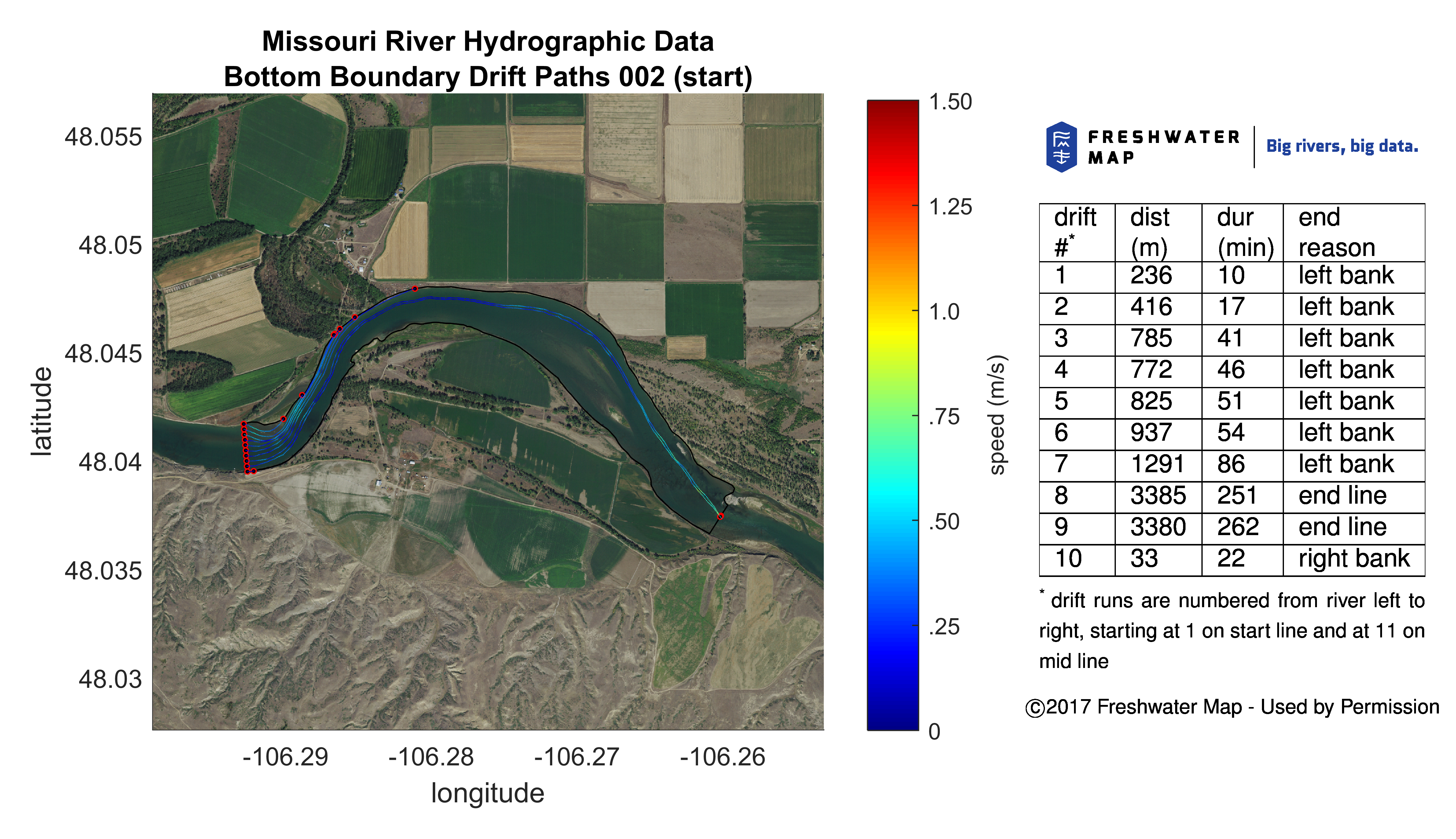
Missouri River, MT and ND — Freshwater Map has collected and analyzed data sets on the Missouri River between Ft. Peck, Montana and Williston, North Dakota to help wildlife managers and dam operators restore populations of pallid sturgeon.  This ancient species of sturgeon has not successfully reproduced in the wild in over 40 years.  Detailed mapping and analysis of habitat will enable scientists to better understand the reasons for the lack of recruitment and help design operational and habitat mitigation strategies to enable the species to thrive.

Client:  Montana Department of Fish, Wildlife and Parks (lead client), with support from Western Area Power Alliance, USGS, Army Corps of Engineers.